Fiction
'Neverwhere' by Neil Gaiman
There are apparently three versions of this book. It began as a television series (1996) prompted by comedian and actor Lenny Henry and written by Gaiman. He then went on to write a book of the series and then a version for American readers who did not understand many of the London references, before this version which is the most comprehensive. A movie was planned in 2009 but never came to anything but a radio series was broadcast in 2013.
I saw the series when first broadcast and watched it last year on DVD. However, I still enjoyed the book which is close to, but does not precisely follow the series. Gaiman has more time to fill in the background and he uses the novel form to really paint the locations and characters of London Below very richly. The book focuses on Richard Mayhew a Scot living in London who goes to the rescue of a young homeless woman, Door. Helping her means he is subsequently invisible to people in London and he is drawn into London Below in an effort to recapture his old life. London Below mixes literal translations of London places, e.g. Old Bailey is an old man who keeps rooks; Earl's Court is a train on which an earl holds court; the Black Friars are friars who are black and so on. It features exotic characters such as the Angel Islington, Mr. Croup and Mr, Vandemar assassins and the amoral Marquis of Carabas, named after a character in the 'Puss in Boots' story. Henry and Gaiman did not want to glamourise the lives of the homeless and so as well as having fantastical elements such as the Floating Market, the Beast of London and the Velvets (as in the Velvet Underground) life is cheap and people Mayhew encounters are tortured and killed with little thought.
Overall it is a modern fairy tale and shows fascinating imagination as you would expect from Gaiman. I enjoyed the book and recommend it if you are looking for something a little different in your fantasy reading as it has elements of many fantasy tropes, but shifts them into a grown-up and gritty context. It may seem very different if you are unfamiliar with London, but I feel it would still be engaging as the places of London Below will be even more unfamiliar.
'Master Georgie' by Beryl Bainbridge
This is an episodic book laid out in reference to a number of photographs taken between 1846-54. The chapters rotate through the three perspectives of people who associate with George Hardy of the title, a rather spoilt young, gay, doctor who has photography as his hobby. Despite his shortcomings he seems to instill great loyalty in his friends and associates. Consequently they move from London to the Crimea as spectators and increasingly participants in the Crimean War. There is very minimal plot. The book is about drawing in great detail the lives and characters of four people, anchored by the focus on Hardy whose perspective we never see. This is very much a 'slice of life' book which is effective in portraying London in the mid-19th century and the squalor and difficulties of the poorly-executed British effort in the Crimean War. It was engaging on that basis, but I like a plot and so finished it feeling a little: 'so what?'. The quality of writing is very good and the historical detail too. Yet, it was not really the book for me.
Showing posts with label London Below. Show all posts
Showing posts with label London Below. Show all posts
Sunday, 30 November 2014


Friday, 17 October 2008
Atlas of Imaginary (and Real) Places 13: An Assortment
Today's selection is an odd assortment of things that I have come across. Some I encountered when I was looking for maps modelled on the London Underground map. They are of real places but shown in a different way to what you might be used to. There is also one fantasy map which got filed in an odd corner of my computer which I ran into recently.
Two come from the SystemeD website. The first one is a map of 'hidden' London and shows in particular the underground rivers and waterways of the city as well as other features which have now been built over. I liked this one as it is reminiscent of the sense of Neil Gaiman's London Below which I have written about before. You can see the Hidden London map in a variety of scales at: http://www.systemed.net/carto/underground.html
This one comes from the following location: http://lndn.blogspot.com/2007_10_01_lndn_archive.html which has lots of delightful and quirky elements about London, its history and culture. This one simply shows the waterway system of London, above ground:
Looking at Tamriel we see both classic elements of fantasy worlds with some attempts to vary it. Having 'Sumerset' (very like the West English county of Somerset in reality) seems a little weak. There are no real inland seas but two long slender channels in Cyrodiil and Morrowind and a decent selection peninsulas, but no archiepelagos that I can see. To some extent the continent seems to have been assembled from blocks and Cyrodiil, Morrowind, Hammerfell and High Rock receiving the most attention and glued together by less elaborate lands. I respect the effort to create something a little different and mix in well-known fantasy concepts with a few different varieties. Clearly this has worked for the people who enjoy this type of computer game otherwise it would not have continued selling over such a long period.
Two come from the SystemeD website. The first one is a map of 'hidden' London and shows in particular the underground rivers and waterways of the city as well as other features which have now been built over. I liked this one as it is reminiscent of the sense of Neil Gaiman's London Below which I have written about before. You can see the Hidden London map in a variety of scales at: http://www.systemed.net/carto/underground.html
Under London Map

This one comes from the following location: http://lndn.blogspot.com/2007_10_01_lndn_archive.html which has lots of delightful and quirky elements about London, its history and culture. This one simply shows the waterway system of London, above ground:
London's Overground Waterways

George Friedman's China Island

Tamriel

Tamriel and other continents

Looking at Tamriel we see both classic elements of fantasy worlds with some attempts to vary it. Having 'Sumerset' (very like the West English county of Somerset in reality) seems a little weak. There are no real inland seas but two long slender channels in Cyrodiil and Morrowind and a decent selection peninsulas, but no archiepelagos that I can see. To some extent the continent seems to have been assembled from blocks and Cyrodiil, Morrowind, Hammerfell and High Rock receiving the most attention and glued together by less elaborate lands. I respect the effort to create something a little different and mix in well-known fantasy concepts with a few different varieties. Clearly this has worked for the people who enjoy this type of computer game otherwise it would not have continued selling over such a long period.
Thursday, 14 August 2008
Atlas of Imaginary Places 11: 'Tube Maps'
As previewed in the previous posting, this one is looking at alternate London Underground maps. I have featured some like 'The Great Bear' and the Gallifrey one in August 2007. This posting has some more including a more thorough German translation one rather than the semi-English/semi-German one I have shown before, though I like the counter-factual implications of that one.
This is the one that got me started, a postcard from the city of Bath in western England. Given that the city is over 2000 years old, it seems odd that they portray it in this modern way. This postcard makes it seem a lot larger than it actually is. It is a very picturesque place with Georgian architecture and extensive Roman remains. One could easily envisage a Bath Below given how much stuff is buried there going back so many centuries. Maybe Neil Gaiman will consider it.
Having seen this, I wondered if other cities had done the same. There were a few from US cities but nothing which leapt out and instead I began encountering the underground map used in different ways. Before progressing, I will show the earliest version from Henry Beck in 1931 which actually shows how much it has progressed. The style today actually looks more 1960s with 1980s overtones than anything from the 1930s despite the emphasis on continuity.


This is the one that got me started, a postcard from the city of Bath in western England. Given that the city is over 2000 years old, it seems odd that they portray it in this modern way. This postcard makes it seem a lot larger than it actually is. It is a very picturesque place with Georgian architecture and extensive Roman remains. One could easily envisage a Bath Below given how much stuff is buried there going back so many centuries. Maybe Neil Gaiman will consider it.
City of Bath 'Underground' Map
I have removed this image as a result of a copyright challenge.
I have removed this image as a result of a copyright challenge.
Having seen this, I wondered if other cities had done the same. There were a few from US cities but nothing which leapt out and instead I began encountering the underground map used in different ways. Before progressing, I will show the earliest version from Henry Beck in 1931 which actually shows how much it has progressed. The style today actually looks more 1960s with 1980s overtones than anything from the 1930s despite the emphasis on continuity.
London Underground Map by Henry Beck

This one was designed for a book called 'Transit Maps of the World' (2007) by Mike Oveden and gives some indications of airline links across the world.

To some extent it is rather like those maps which show contries by the magnitude of something that they are involved in such as consumption of electricity and you see that Spain and Portugal for example are portrayed about a third of the size of the whole of Africa and similarly the Middle East is extended, in both cases reflecting the amount of airline traffic iin comparison to the geographical sizes of these regions
London Underground Map in German

This is the promised one more properly rendering the stations into German. Though this then makes it appear more like just a tourist tool than the implications of a collaborationist regime in the style of 'SS-GB' or perhaps 'When William Came' suggested by the less thorough one I have shown before. I guess for all British people showing familiar things in German still has echoes because even the current generation often defines itself in reference to being opposed to anything German despite the fact that most grandparents were only children when the last war against Germany finished.
Now, I move away from the geographical to the intellectual. The London Underground styling is often used almost like a mindmap to illustrate in a somehow tangible way things which are really intangible. The simplest one I have found is this one which almost seems to be axes of taste in culture:
Understated Tube Mind-Map

This one is reminiscent of those maps that look like ones of fantasy worlds but in fact show groupings and developments on the internet. This one shows what are seen as current trends in global society and how they inter-relate to people. It has Chinese characters, which in itself can be seen as a trend, but may also hint at a source. It is interesting that whoever it came from is less imbued with the fantasy map background and clearly is more familiar with the portrayal of actual cities. Perhaps by adopting this style they felt it would gain more credibility than a fantasy-style map. Looking at it, it does not resemble the London Undeground map but one of the maps from other cities like the Paris Metro system or most likely a system in Beijing or Shanghai.
Trend Blend Urban Transport Style Map (2008)

The following one is similar but again focused purely on the internet and seems closer to the London Underground mapping. I do wonder if in 2008 that this style is seen as cool and serious compared to the fantasy world map style of the past few years that were used to illustrate such things.
Web Trend Map (2008)

Rather than go with one of the numerous music style maps which I know less about, though I may come back to them in the future, I was attracted to this one from the Royal Shakespeare Company. It is reminiscent of 'The Great Bear' and that might be indicated by the title they have adopted. It features Shakespeare characters and the mapping to some extent shows the relationships between them. I must say this is one of my favourites and it goes beyond the simply conceptual basis. I also like the little icons next to some of the 'stations' too. I would love it if the underground stations were labelled by Shakespeare characters. Given that the main point of access for millions of people each year to poetry is simply by the Poems On The Underground scheme which started in 1986 (it means poems are put up in advertising slots in underground train carriages), then why should not more of their journey be influenced by literature?
Greater Shakespeare Underground Map

This final one is just a comic one, substituting various foods ('grub' is an old UK slang term for food) for the underground stations. I do wonder why Transport For London went after the Geoff Marshall one and not this one which in my mind could appear more insulting, though in fact I feel they are all delightful and bring attention and respect to the London Underground system and its iconography.
Undergrub Map

Saturday, 18 August 2007
An Atlas of Imaginary Worlds 5: Worlds Beside Our Own
Having span off into the world of the Hollow Earth, there remain a couple of worlds set on or rather beside the Earth we know that I thought were worth mentioning. The first comes from the movie 'Time Bandits' (1981). This was produced by former Beatle, George Harrison and written by Michael Palin and Terry Gilliam (who also directed it) who had been in the cult comedy 'Monty Python's Flying Circus' and in spin-off movies like 'Jabberwocky' (1977) and 'The Life of Brian' (1979 - which has gone from being condemned by Christian groups as ungodly, to now since even the early 1990s having clips used in children's history programmes about the Romans). Most of the 'Pythons' attended with Oxford or Cambridge university, one of them, Terry Jones, since 1984, has been writing books such as 'Chaucer's Knight' (1984) and producing programmes on medieval history and Palin has gone on to be a successful adventurous travel writer with books and programmes amongst others, 'Around the World in 80 Days' (1991), 'Pole to Pole' (1992), 'Sahara' (2002) and 'Full Circle' (2004) so their historical facts tend to be very solid as can be seen in their films).
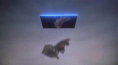
Anyway, 'Time Bandits' is a popular blog topic. It is really a children's film about an English boy from 1981 called Kevin and 6 dwarfs who work for the 'Supreme Being' and have a map of flaws in the universe which allow them to jump through time and space on Earth. Portals open up for a limited amount of time, giving an urgency to their explorations as seen in this blurred image from the movie:
 They are supposed to be repairing them, but use them to go round stealing treasure. The map they use is bigger than any one of them and I think some of the appeal of it, is its aesthetic. It looks as it should, cryptic and mystical, but practical too, though with potential for misinterpretation. Below are some images of the map as seen in the movie and now available to buy. The fact that people still want it 26 years later, suggests it has a pretty iconic status. Like a lot of Gilliam's work, notably 'Brazil' (1985), 'The Adventures of Baron Munchhausen' (1988), 'The Fisher King' (1991) and his abortive Don Quixote film, it is about preserving fantasy and excitement in a world obsessed with rationality, and especially in 'Time Bandits', consumerism. In Gilliam's view, it appears such ability to engage with the unreal is what keeps us free.

 The map as seen in the movie:
 This one was a similar map produced by the artist Jennifer Diane Reitz in the early 1980s. See: http://www.pasteldefender.com/news.html for more about her and her work, a lot of which falls into fantasy categories:
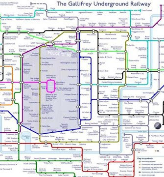
 I had hoped to be able to find a Neverwhere map. 'Neverwhere' (1998) was by Neil Gaiman, the (graphic) based on a television series by him (and the comedian Lenny Henry) of the same name in 1996. It envisages a parallel world within London; London Below. All those mysterious doors you pass that no-one ever seems to open or those windowed spires on the top of Victorian buildings, actually go into this different world, inhabited both by tribes of homeless people and by fantastical creatures. All the places on the London undeground map relate to real things so an earl has a court at Earl's Court, there is a black smith at Hammersmith, there are black friars from Blackfriars (and the female vampires, the Velvets come in, as in The Velvet Underground) and there is an angel at Angel Islington and so on. I know there are lots of closed down stations on the London underground, but I suppose Gaiman's Neverwhere map would be the same as the London Underground one anyway. So I found some other unusual or faked underground railway maps, including one for the planet Gallifrey the home planet of the Doctor in the television series 'Doctor Who' (intermittently 1963- Now). The first is a map which shows the geographical rather than schematic map of the routes which usually is seen. Another one to look out for is 'The Great Bear' (1992) by Simon Patterson a conceptual map based on the traditional London Underground map outline:


 The final one for now is a 'map' that seems to be all over the internet maybe influenced by the very speculative ones drawn by explorers in the 19th century, but certainly one which could provide a model for those seeking to create fantasy world maps now. Note both the inland sea and the northern mountains and wastelands:

On reflection, though, I think that this was not supposed to be satirical in the way it now seems to be portrayed, rather it was probably an aide-memoire for Victorian children to show them the generic elements of what they would find on a map. However, it would be tempting to write over the labels and use it as a fantasy world.
Anyway, 'Time Bandits' is a popular blog topic. It is really a children's film about an English boy from 1981 called Kevin and 6 dwarfs who work for the 'Supreme Being' and have a map of flaws in the universe which allow them to jump through time and space on Earth. Portals open up for a limited amount of time, giving an urgency to their explorations as seen in this blurred image from the movie:


On reflection, though, I think that this was not supposed to be satirical in the way it now seems to be portrayed, rather it was probably an aide-memoire for Victorian children to show them the generic elements of what they would find on a map. However, it would be tempting to write over the labels and use it as a fantasy world.
Subscribe to:
Posts (Atom)


